A new series of high-resolution maps of Irelands coast is being released and made available to the public for free.
INFOMAR (Integrated Mapping for the Sustainable Development of Ireland’s Marine Resource) has launched the Blue Scale Map Series; a collection of 18 high-resolution bathymetric maps of Ireland’s coastal waters. Developed by a dedicated team of hydrographers, data processors and cartographers, the maps highlight the topography of the coast in unprecedented detail.
In 2006, the INFOMAR programme was established and is currently one of the world’s largest and leading seabed mapping programmes. The programme, funded by the Department of the Environment, Climate and Communications, is a joint venture by Geological Survey Ireland and the Marine Institute and aims to map Ireland’s seabed and deliver a comprehensive baseline bathymetry dataset to underpin the future management of Ireland’s marine resource.
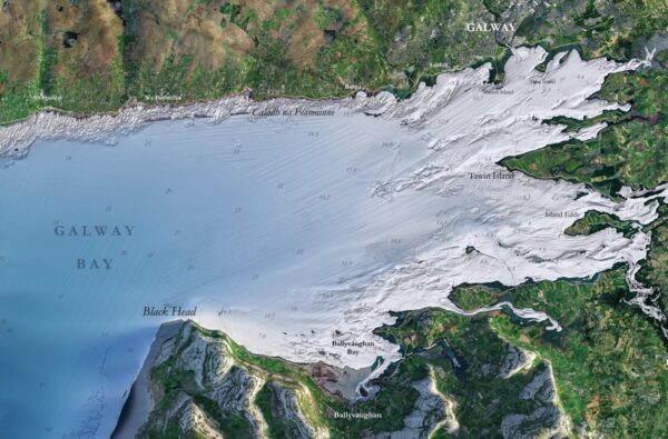
The Blue Scale Map Series is the culmination of over a decade of work. INFOMAR will be releasing a new map of a different section of the Irish coastline every week. The first in the series is the bluescale bathymetric map of Galway Bay.
INFOMAR is making all 18 maps available for free to the public to download in high resolution JPEG format. You can read more and find the maps here.