The Environment Agency has published new data showing 6.3 million properties across England are based in areas at risk of flooding from one or a combination of rivers, the sea and surface water.
Using the best available data from both the Environment Agency and local authorities, the new National Assessment of Flood Risk (NaFRA), provides a single and updated picture of the current and future flood risk from rivers, the sea and surface water for England. The last update to NaFRA was in 2018.
Alongside this, the Environment Agency has also updated the National Coastal Erosion Risk Map (NCERM) for the first time since 2017. This provides the most up to date national picture of the current and future coastal erosion risk for England using the best available evidence from the National Network of Regional Coastal Monitoring Programmes.
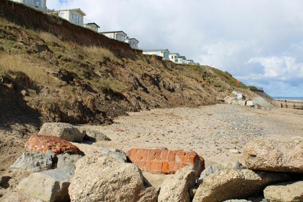
Photo: Arjan Billan
These updated assessments provide a clearer understanding of flood risk around the country and the data will be used by the government, Environment Agency and local communities to plan for and improve flood resilience in areas at risk.
Around 2.4 million properties are in areas at risk of flooding from rivers and the sea. While the total number of properties at risk is not increasing, there is an 88% increase in the number of properties at the highest levels of risk, where an area has a greater than one in 30 chance of flooding in any given year. There are a variety of reasons for this change in risk, the most notable being improved data and modelling methods for assessing the likely frequency of flooding.
With climate change, the total number of properties in areas at risk from rivers and the sea or surface water could increase to around 8 million by the middle of the century – or around one in four properties.
The Environment Agency’s updated assessment also shows how coastal erosion risk is changing across our shorelines, with 3,500 properties expected to be in areas at risk of coastal erosion in the period up to 2055, increasing to about 10,100 properties by the end of the century.
Julie Foley, Director of Flood Risk Strategy at the Environment Agency said: Our updated assessment shows there are 6.3 million properties in England in areas at risk of flooding from rivers, the sea or surface water. When we account for the latest climate projections, one in four properties could be in areas at risk of flooding by the middle of the century.
Stewart Rowe, Chair of the Coastal Group Network, said: The updated coastal erosion risk information will be critical to the implementation of the Shoreline Management Plans that set out our long-term approach to managing flood and coastal erosion risk around the coast.