Enhanced mapping of the UK’s Exclusive Economic Zone (EEZ) is being made available to the public for the first time, providing greater insight into the occurrence of earthquake hazard across an area of seabed that the country holds exclusive rights to, including those for energy production.
The updated modelling from British Geological Survey (BGS) comes at a time when the UK is seeking to bolster its offshore renewable energy infrastructure and meet its net zero commitments.
Dr Ilaria Mosca, earthquake hazard researcher at the BGS said: “These maps are the first new UK offshore seismic hazard maps for more than 20 years. Methodological and computational advances mean that we are able to better understand which areas hold the potential to be heavily impacted by seismic activity and how to model the uncertainty (what is still unknown or uncertain).
Offshore critical infrastructure, including windfarms and carbon capture and storage, are both essential for the transition to net zero, but it is also vital that we know what the hazard is so that high consequence structures can be designed appropriately to reduce risks to people and the environment.”
Earthquakes in the UK
The UK experiences 200-300 earthquakes annually, with the largest being a 6.1 magnitude quake in 1931 in the Dogger Bank area. More recently, a 5.2 magnitude earthquake in 2022 shut down operations at an offshore oil platform in the North Sea.
With increasing carbon capture and storage (CCS) sites in the North and Irish Seas, robust estimates of earthquake hazards are vital for planning. Seismic hazard maps are based on historical data and tectonic information to model earthquake risks and ground shaking.
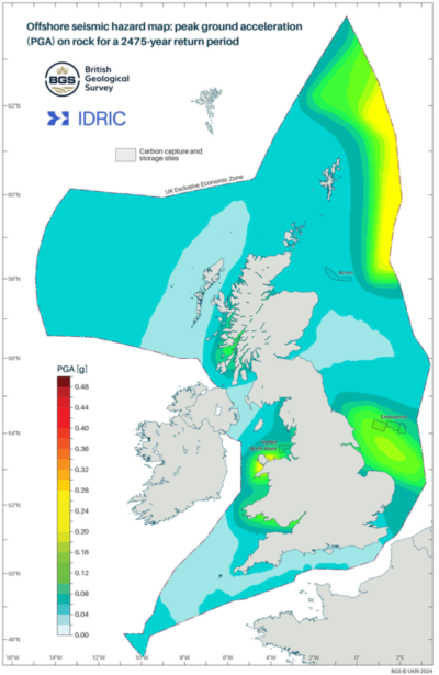 The new offshore seismic hazard map: peak ground acceleration on sock for the 2475 year return period. Crown copyright and database right 2024.
Dr Mosca added: “These maps empower developers with the knowledge of the areas that have the greatest potential for key infrastructure, including CCS, to be built without the serious risk of damage caused by the ground shaking produced by future potential earthquakes, helping to ensure net zero can be achieved alongside the safety of those on and offshore.”